
Mars Pathfinder Science Objectives
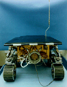
The Mars Pathfinder project is one of the first NASA Discovery class
missions. It will land a single vehicle with a microrover
(Sojourner) and several instruments on the surface of Mars in 1997.
Sojourner's mobility provides the capability of "ground truthing"
a landing area over hundreds of square meters on Mars. Pathfinder will be
investigating the surface of Mars with three additional science instruments
(a stereoscopic imager with spectral filters on an extendible mast (IMP)), an Alpha Proton X-Ray Spectrometer (APXS), and an Atmospheric Structure Instrument/Meteorology
package (ASI/MET). These insturments will
allow investigations of the geology and surface morphology at sub-meter
to a hundred meters scale, the geochemistry and petrology of soils and rocks,
the magnetic and mechanical properties of the soil as well as the magnetic
properties of the dust, a variety of atmospheric investigations and rotational
and orbital dynamics of Mars. Landing downstream from the mouth of a giant
catastrophic outflow channel (Ares
Vallis) offers the potential for identifying and analyzing a wide variety
of crustal materials, from the ancient heavily cratered terrains to intermediate-aged
ridged plains to reworked channel deposits. Examination of the different
surface materials will allow first-order scientific
investigations of the early differentiation and evolution of the crust,
the development of weathering products and the early environments and conditions
that have existed on Mars.
Suface Morphology and Geology at Meter Scale
 The Imager
For Mars Pathfinder (IMP) will reveal martian geologic processes and
surface-atmosphere interactions similar to what was observed at the viking
landing sites. Observations of the general landscape, surface slopes and
the distribution of rocks will be obtained by panoramic stereo images at
various times of the day. Any changes in the scene over the lifetime of
the mission might be attributed to the actions of frost, dust or sand deposition,
erosion or other surface-atmosphere interactions. A basic understanding
of the surface and near-surface soil properties will be obtained by the
Rover and lander imaging of rover
wheel tracks, holes dug by the rover wheels, and any surface disruptions
caused by airbag bounces or retractions.
The Imager
For Mars Pathfinder (IMP) will reveal martian geologic processes and
surface-atmosphere interactions similar to what was observed at the viking
landing sites. Observations of the general landscape, surface slopes and
the distribution of rocks will be obtained by panoramic stereo images at
various times of the day. Any changes in the scene over the lifetime of
the mission might be attributed to the actions of frost, dust or sand deposition,
erosion or other surface-atmosphere interactions. A basic understanding
of the surface and near-surface soil properties will be obtained by the
Rover and lander imaging of rover
wheel tracks, holes dug by the rover wheels, and any surface disruptions
caused by airbag bounces or retractions.
Petrology and Geochemistry of Surface Materials
 The Alpha-Proton
X-Ray Spectrometer (APXS) and the visible to near-infrared spectral
filters on the imp will determine the dominant elements that make up the
rocks and other surface materials of the landing site. A better understanding
of these materials will address questions concerning the composition of
the martian crust, as well as secondary weathering products (such as different
types of soils). These investigations will provide a calibration point for
orbital remote sensing observations such as Mars
Global Surveyor. The IMP will be able to obtain full multi-spectral
panoramas of the surface and underlying materials exposed by the rover and
lander. since the APXS is mounted on the rover, it will be able to characterize
rocks and soils in the vicinity of the lander.
The Alpha-Proton
X-Ray Spectrometer (APXS) and the visible to near-infrared spectral
filters on the imp will determine the dominant elements that make up the
rocks and other surface materials of the landing site. A better understanding
of these materials will address questions concerning the composition of
the martian crust, as well as secondary weathering products (such as different
types of soils). These investigations will provide a calibration point for
orbital remote sensing observations such as Mars
Global Surveyor. The IMP will be able to obtain full multi-spectral
panoramas of the surface and underlying materials exposed by the rover and
lander. since the APXS is mounted on the rover, it will be able to characterize
rocks and soils in the vicinity of the lander.
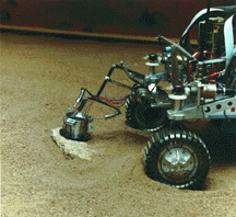
Magnetic Properties and Soil Mechanics of the Surface
 Magnetic targets are distributed at various
points around the spacecraft. Multi-spectral images of these targets will
be used to identify the magnetic minerals which make up airborne dust. In
addition, APXS measurement taking of the material collected on the magnetic
targets will determine the presence of titanium and iron in the dust. Using
a combination of the images, and APXS measurements, it is possible that
the mineral composition of the rocks can be inferred. Detailed examination
of the wheel-track images will give a better understanding of the mechanics
of the soil surrounding the landing site.
Magnetic targets are distributed at various
points around the spacecraft. Multi-spectral images of these targets will
be used to identify the magnetic minerals which make up airborne dust. In
addition, APXS measurement taking of the material collected on the magnetic
targets will determine the presence of titanium and iron in the dust. Using
a combination of the images, and APXS measurements, it is possible that
the mineral composition of the rocks can be inferred. Detailed examination
of the wheel-track images will give a better understanding of the mechanics
of the soil surrounding the landing site.
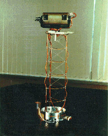
Atmospheric Structure as Well as Diurnal and Seasonal Meteorological
Variations
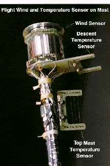 The Atmospheric
Structure Instrument/Meteorology (ASI/MET) experiment will be able to
determine the temperature and density of the atmosphere during Entry, Descent and Landing (EDL). In addition, three-axis
accelerometers will be used to measure atmospheric pressure during this
period. Once on the surface, meteorological measurements such as pressure,
temperature, wind speed and atmospheric opacity will be obtained on a daily
basis. Thermocouples mounted on a meter-high mast will examine temperature
profiles with height. wind direction and speed will be measured by a wind
sensor mounted at the top of the mast, as well as three wind socks interspersed
at different heights on the mast. Understanding this data is very important
for identifying the forces which act on small particles carried by the wind.
Regular sky and solar spectral observations using the IMP will monitor windborne
particle size, particle shape, distribution with altitude and the abundance
of water vapor.
The Atmospheric
Structure Instrument/Meteorology (ASI/MET) experiment will be able to
determine the temperature and density of the atmosphere during Entry, Descent and Landing (EDL). In addition, three-axis
accelerometers will be used to measure atmospheric pressure during this
period. Once on the surface, meteorological measurements such as pressure,
temperature, wind speed and atmospheric opacity will be obtained on a daily
basis. Thermocouples mounted on a meter-high mast will examine temperature
profiles with height. wind direction and speed will be measured by a wind
sensor mounted at the top of the mast, as well as three wind socks interspersed
at different heights on the mast. Understanding this data is very important
for identifying the forces which act on small particles carried by the wind.
Regular sky and solar spectral observations using the IMP will monitor windborne
particle size, particle shape, distribution with altitude and the abundance
of water vapor.
Rotational and Orbital Dynamics of Mars
The Deep Space Network (DSN),
by using two-way X-Band and doppler tracking of the Mars Pathfinder lander
will be able to address a variety of orbital and rotational dynamics questions.
Ranging involves sending a ranging code to the lander on mars and measuring
the time required for the lander to echo the code back to the Earth-based
station. dividing this time by the speed of light results in an accurate
measurement (within 1-5 meters) of the distance from the station to the
spacecraft. As the lander moves relative to the tracking station, the velocity
between the spacecraft and Earth causes a shift in frequency (doppler shift).
Measuring this frequency shift provides an accurate measurement of the distance
from the station to the lander. Within a few months of observing these features,
the Mars Pathfinder lander location can be determined within a few meters.
Once the exact location of Pathfinder has been identified, the orientation
and precession rate (regular motion of the pole with respect to the ecliptic)
of the pole can be calculated and compared to measurements made with the
Viking landers 20 years ago. Measurement of the precession rate allows direct
calculation for the moment of inertia, which is in turn controlled by the
density of the martian rock with depth. Measurements similar to these are
used on earth to determine the makeup of the earth's interior.
Back to the Mars Pathfinder Home Page