S0184.jpg |

S0185.jpg |
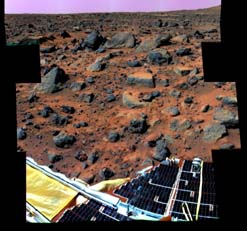
Super-pan octant S0184 This enhanced color image mosaic of the Rock Garden
area west of the lander was made using images acquired in the mid-morning
of Sol 32 by the IMP camera as part of the Super-Pan data set.
At each camera frame position, a Super-Pan image contains fifteen frames---six
frames for three-color stereo and nine more individual narrow color bands.
This mammoth color and stereo data set will be used to derive high quality
topographic maps of the surface and detailed shapes of rocks and other surface
features, and to map subtle chemical, mineralogical, and textural variations
on rocks and soils. Red, green, and blue filter images from the right eye
were combined to simulate slightly amplified natural color. The "bookshelf"
rocks visible in the background include Shark, Half-Dome, Moe, and Stimpy.
The rover Sojourner completed imaging and APXS measurements of these rocks
on Sol 71. Small rocks below and to the right of Flat Top appear to have
been moved and/or pushed into the soil, probably by the spacecraft during
landing. A portion of South Peak is visible in the upper right corner of
the mosaic. One of the solar-panel-covered lander petals and the forward
rover ramp are visible in the foreground. The Processing of this mosaic
was done by the United States Geological Survey, Flagstaff, Arizona. |
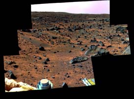
This enhanced color image mosaic of the area south of the lander was
made using images acquired in the mid-morning of Sol 13 by the IMP camera
as part of the Super-Pan data set.
At each camera frame position, a Super-Pan image contains fifteen frames---six
frames for three-color stereo and nine more individual narrow color bands.
This mammoth color and stereo data set will be used to derive high quality
topographic maps of the surface and detailed shapes of rocks and other surface
features, and to map subtle chemical, mineralogical, and textural variations
on rocks and soils. Red, green, and blue filter images from the right eye
were combined to simulate slightly amplified natural color. The rocks Squid,
Ender, Hassock, and a portion of Wedge are visible in the center-right portion
of the mosaic. Mermaid Dune and Bosco rock are visible in the middle-left.
The foreground contains portions of the airbags and the top of the low-gain
antenna on the lander. The rim of the impact crater "Big Crater"
is visible in the upper-left on the horizon. The processing of this mosaic
was done by the United States Geological Survey, Flagstaff, Arizona. |

S0188.jpg |

windsock_sol73.jpg |
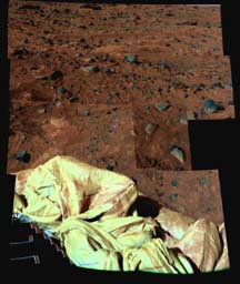
This preliminary enhanced color image mosaic of the area northeast
of the lander was made using images acquired in the afternoon of Sol 20
(top portion of the mosaic) and Sol 38 (bottom portion of the mosaic) by
the IMP camera as part of the Super-Pan data set. The differences in brightness
between the upper and lower portions of the mosaic result from slightly
different sun angle positions between Sols 20 and 38, and can be compensated
by subsequent analysis of the reflectance of surface rocks and soils under
different lighting conditions.
At each camera frame position, a Super-Pan image contains fifteen frames---six
frames for three-color stereo and nine more individual narrow color bands.
This mammoth color and stereo data set will be used to derive high quality
topographic maps of the surface and detailed shapes of rocks and other surface
features, and to map subtle chemical, mineralogical, and textural variations
on rocks and soils. Red, green, and blue filter images from the right eye
were combined to simulate slightly amplified natural color. The bright,
flat areas Scooby Doo and Baker's Bench are visible left of center and above
center in the mosaic, respectively. Airbags and a portion of one of the
lander petals are visible in the foreground. The processing of this mosaic
was done by the United States Geological Survey, Flagstaff, Arizona. |
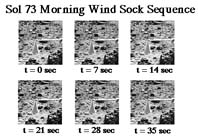
This sequence of images shows the Pathfinder upper wind sock on the morning
of Sol 73 (September 16). The interval between frames is one second. There
is no obvious movement of the sock, indicating little or no wind at this
elevation (about 1 meter above the surface). At other times during the mission,
deflections of this and two lower wind socks have been used to estimate
characteristics of the wind speed boundary layer profile. |
|
|
| This stereo image pair taken on the afternoon of Sol 74 (September
17) shows the Sojourner rover behind the rock "Chimp." Sojourner
is now a record 12.3 m from the lander. |
|
|
| These two views of the rock "Chimp" were acquired by the Sojourner
rover's right front camera on Sol 74 (September 17). A large crack, oriented
from lower left to upper right, is visible in the rock. A dark crust appears
to cover Chimp in some areas whereas other parts of the rock have a lighter
shading. A boundary between the two regions is clearly seen in the upper
left part of Chimp. |
|
|
| This stereo image pair shows the Sojourner rover behind the large rock "Chimp"
near noontime on Sol 75 (September 18). The rover's middle right wheel is
raised above the surface. Sojourner is over 12 m from the lander, a mission
record. |
MARS PATHFINDER MISSION STATUS
19 September 1997, 9:30 p.m. PDT
All Sol 76 up link and down link activities have been completed.
Following yesterdays down link rain out, todays's forecast
once again called for more soggy weather over the deep space network station
in Canberra Australia. However, the rain held off today and we were able
to maintain a high data rate thought the entire Sol 76 down link . Telemetry
returned from Mars today indicated that our Martian dwellers continue to
be in good health after 2.5 months on the surface on the red planet. The
rover had another successful day and images lost during yesterday's rain
were retaken today and received on the ground. The rover obtained images
behind the rock "Book Case" which is an area the lander is unable
to see.
After acquiring the images the rover moved to the next target
which is the rock "Chimp". The rover stopped about a half meter
to the left of this rock because telemetry indicated a stall in the left
rear wheel which was possibly caused by a pebble being stuck in the wheel.
This has occurred in the past and the rover should be able to clear this
condition on its own.
The plan for tomorrow calls for completing the move to the
rock Chimp in preparation for placing the APXS on the rock.
More high rate data should be receive around 7:00 PM PDT tomorrow.
For further information on the Mars Pathfinder Mission, please
call our Mission Status Report line at 1-800-391-6654. |