 |
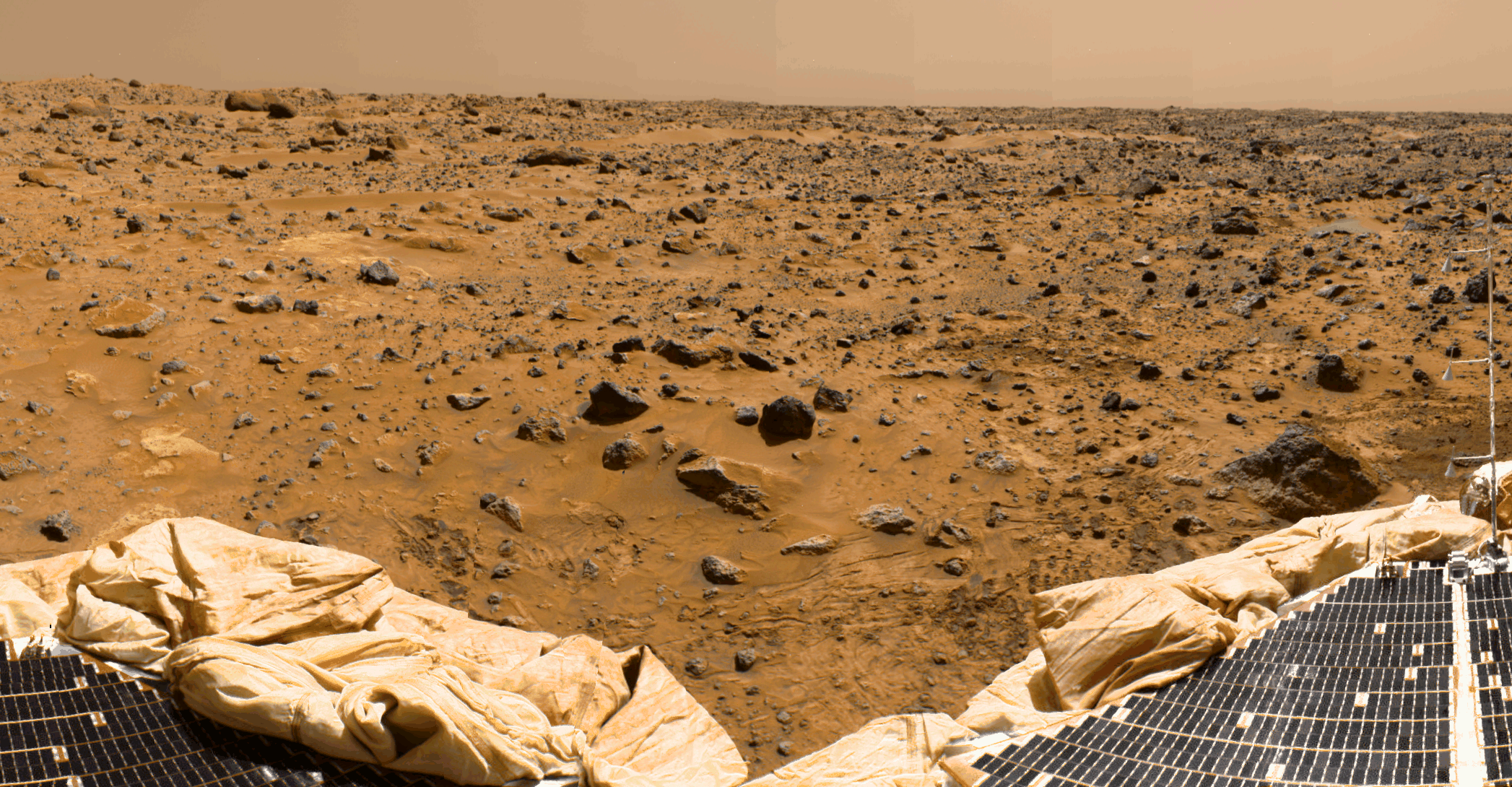
This is a sub-section of the "geometrically improved, color enhanced" version of the 360-degree panorama heretofore known as the "Gallery Pan", the first contiguous, uniform panorama taken by the Imager for Mars Pathfinder (IMP) over the course of Sols 8, 9, and 10. Different regions were imaged at different times over the three Martian days to acquire consistent lighting and shadow conditions for all areas of the panorama. The IMP is a stereo imaging system that, in its fully deployed configuration, stands 1.8 meters above the Martian surface, and has a resolution of two millimeters at a range of two meters. In this geometrically improved version of the panorama, distortion due to a 2.5 degree tilt in the IMP camera mast has been removed, effectively flattening the horizon. The IMP has color capability provided by 24 selectable filters -- twelve filters per "eye". Its red, green, and blue filters were used to take this image. The color was digitally balanced according to the color transmittance capability of a high-resolution TV at the Jet Propulsion Laboratory (JPL), and is dependent on that device. In this color enhanced version of the panorama, detail in surface features are brought out via changes to saturation and intensity, holding the original hue constant. A threshold was applied to avoid changes to the sky. At left is a Lander petal and a metallic mast which is a portion of the low-gain antenna. Misregistration in the antenna and other Lander features is due to parallax in the extreme foreground. Another Lander petal is at the right, showing the fully deployed forward ramp. Mars Pathfinder is the second in NASA's Discovery program of low-cost spacecraft with highly focused science goals. The Jet Propulsion Laboratory, Pasadena, CA, developed and manages the Mars Pathfinder mission for NASA's Office of Space Science, Washington, D.C. JPL is an operating division of the California Institute of Technology (Caltech). The IMP was developed by the University of Arizona Lunar and Planetary Laboratory under contract to JPL. Peter Smith is the Principal Investigator. |
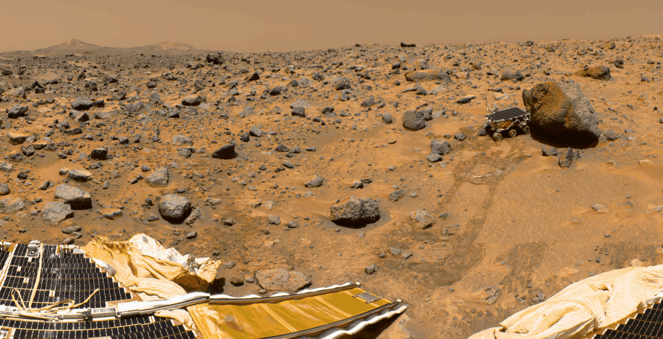 |
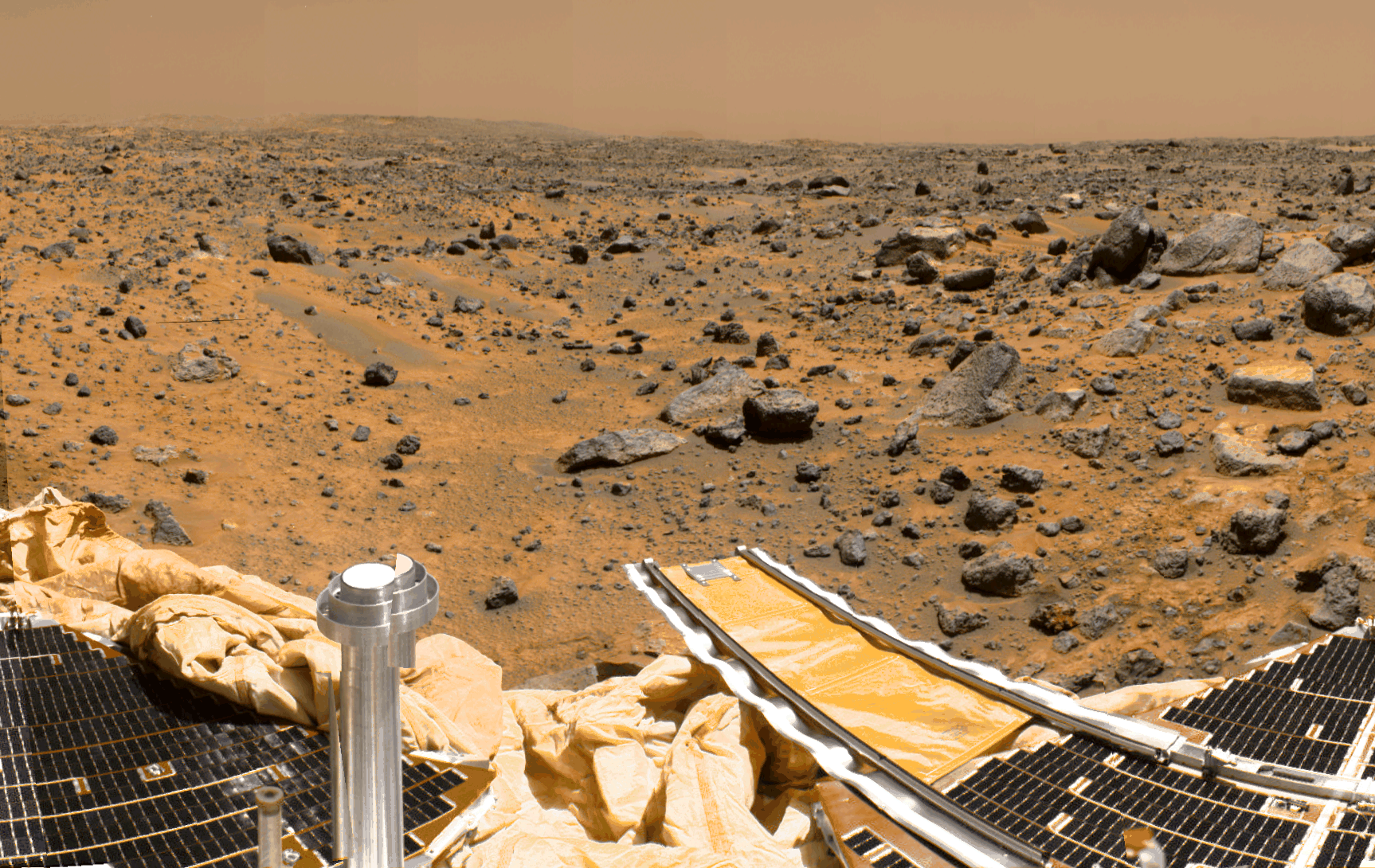
This is a sub-section of the "geometrically improved, color enhanced" version of the 360-degree panorama heretofore known as the "Gallery Pan", the first contiguous, uniform panorama taken by the Imager for Mars Pathfinder (IMP) over the course of Sols 8, 9, and 10. Different regions were imaged at different times over the three Martian days to acquire consistent lighting and shadow conditions for all areas of the panorama. The IMP is a stereo imaging system that, in its fully deployed configuration, stands 1.8 meters above the Martian surface, and has a resolution of two millimeters at a range of two meters. In this geometrically improved version of the panorama, distortion due to a 2.5 degree tilt in the IMP camera mast has been removed, effectively flattening the horizon. The IMP has color capability provided by 24 selectable filters -- twelve filters per "eye". Its red, green, and blue filters were used to take this image. The color was digitally balanced according to the color transmittance capability of a high-resolution TV at the Jet Propulsion Laboratory (JPL), and is dependent on that device. In this color enhanced version of the panorama, detail in surface features are brought out via changes to saturation and intensity, holding the original hue constant. A threshold was applied to avoid changes to the sky. On the horizon the double "Twin Peaks" are visible, about 1-2 kilometers away. The rock "Couch" is the dark, curved rock at right of Twin Peaks. A Lander petal is visible on the left, showing the fully deployed rear ramp, which rover Sojourner used to descend to the surface of Mars on July 5. Immediately to the left of the rear ramp is the rock "Barnacle Bill", which scientists found to be andesitic, possibly indicating that it is a volcanic rock (a true andesite) or a physical mixture of particles. Just beyond Barnacle Bill, rover tracks lead to Sojourner, shown using its Alpha Proton X-Ray Spectrometer (APXS) instrument to study the large rock "Yogi". Yogi, low in quartz content, appears to be more primitive than Barnacle Bill, and appears more like the common basalts found on Earth. The tracks and circular pattern in the soil leading up to Yogi were part of Sojourner's soil mechanics experiments, in which varying amounts of pressure were applied to the wheels in order to determine physical properties of the soil. During its traverse to Yogi the rover stirred the soil and exposed material from several centimeters in depth. During one of the turns to deploy Sojourner's Alpha Proton X-Ray Spectrometer, the wheels dug particularly deeply and exposed white material. Spectra of this white material show it is virtually identical to the rock "Scooby Doo", and such white material may underlie much of the site. Deflated airbags are visible at the perimeter of the Lander petals. Mars Pathfinder is the second in NASA's Discovery program of low-cost spacecraft with highly focused science goals. The Jet Propulsion Laboratory, Pasadena, CA, developed and manages the Mars Pathfinder mission for NASA's Office of Space Science, Washington, D.C. JPL is an operating division of the California Institute of Technology (Caltech). The IMP was developed by the University of Arizona Lunar and Planetary Laboratory under contract to JPL. Peter Smith is the Principal Investigator. |
 |
This is a sub-section of the "geometrically improved, color enhanced" version of the 360-degree panorama heretofore known as the "Gallery Pan", the first contiguous, uniform panorama taken by the Imager for Mars Pathfinder (IMP) over the course of Sols 8, 9, and 10. Different regions were imaged at different times over the three Martian days to acquire consistent lighting and shadow conditions for all areas of the panorama. The IMP is a stereo imaging system that, in its fully deployed configuration, stands 1.8 meters above the Martian surface, and has a resolution of two millimeters at a range of two meters. In this geometrically improved version of the panorama, distortion due to a 2.5 degree tilt in the IMP camera mast has been removed, effectively flattening the horizon. The IMP has color capability provided by 24 selectable filters -- twelve filters per "eye". Its red, green, and blue filters were used to take this image. The color was digitally balanced according to the color transmittance capability of a high-resolution TV at the Jet Propulsion Laboratory (JPL), and is dependent on that device. In this color enhanced version of the panorama, detail in surface features are brought out via changes to saturation and intensity, holding the original hue constant. A threshold was applied to avoid changes to the sky. At the bottom of the image, two of the Lander petals are visible. At the extreme right of the image, the Atmospheric Structure Instrument and Meteorology package (ASI/MET) mast, with it's three windsocks, is visible. Mars Pathfinder is the second in NASA's Discovery program of low-cost spacecraft with highly focused science goals. The Jet Propulsion Laboratory, Pasadena, CA, developed and manages the Mars Pathfinder mission for NASA's Office of Space Science, Washington, D.C. JPL is an operating division of the California Institute of Technology (Caltech). The IMP was developed by the University of Arizona Lunar and Planetary Laboratory under contract to JPL. Peter Smith is the Principal Investigator. |
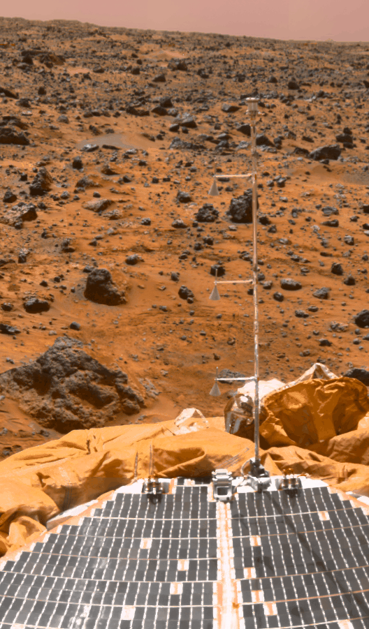 |
| The Mars Pathfinder meteorology mast casts a shadow on the lander solar array, as seen in this superpan mosaic. Looking to the southeast during the morning, the windsocks are slightly tilted, indicating the presence of a light wind from the southwest. The MET mast measured the temperature, pressure, and wind speed at the Pathfinder landing site. During the mission, the instrument returned 8.5 million individual measurements from the surface of Mars. |
|
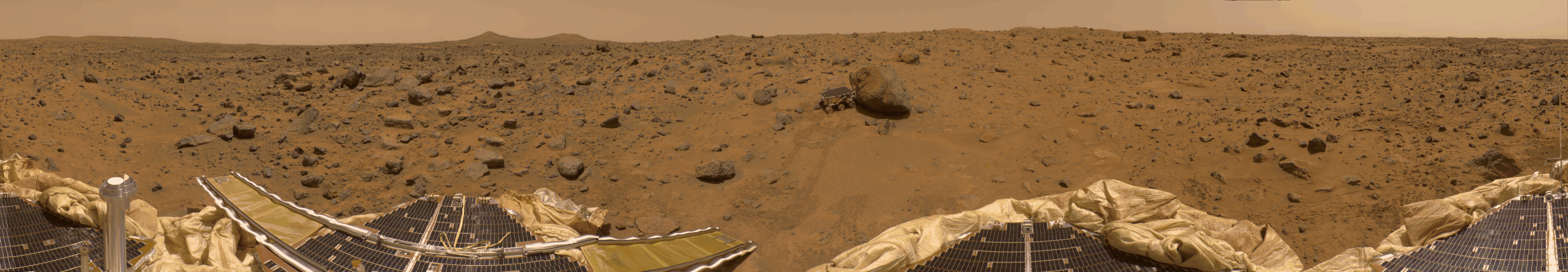
This is a "geometrically improved" version of the 360-degree panorama heretofore known as the "Gallery Pan", the first contiguous, uniform panorama taken by the Imager for Mars Pathfinder (IMP) over the course of Sols 8, 9, and 10. Different regions were imaged at different times over the three Martian days to acquire consistent lighting and shadow conditions for all areas of the panorama. The IMP is a stereo imaging system that, in its fully deployed configuration, stands 1.8 meters above the Martian surface, and has a resolution of two millimeters at a range of two meters. In this geometrically improved version of the panorama, distortion due to a 2.5 degree tilt in the IMP camera mast has been removed, effectively flattening the horizon. The IMP has color capability provided by 24 selectable filters -- twelve filters per "eye". Its red, green, and blue filters were used to take this image. At left is a Lander petal and a metallic mast which is a portion of the low-gain antenna. Misregistration in the antenna and other Lander features is due to parallax in the extreme foreground. On the horizon the double "Twin Peaks" are visible, about 1-2 kilometers away. The rock "Couch" is the dark, curved rock at right of Twin Peaks. Another Lander petal is at left-center, showing the fully deployed forward ramp at far left, and rear ramp at right, which rover Sojourner used to descend to the surface of Mars on July 5. Immediately to the left of the rear ramp is the rock "Barnacle Bill", which scientists found to be andesitic, possibly indicating that it is a volcanic rock (a true andesite) or a physical mixture of particles. Just beyond Barnacle Bill, rover tracks lead to Sojourner, shown using its Alpha Proton X-Ray Spectrometer (APXS) instrument to study the large rock "Yogi". Yogi, low in quartz content, appears to be more primitive than Barnacle Bill, and appears more like the common basalts found on Earth. The tracks and circular pattern in the soil leading up to Yogi were part of Sojourner's soil mechanics experiments, in which varying amounts of pressure were applied to the wheels in order to determine physical properties of the soil. During its traverse to Yogi the rover stirred the soil and exposed material from several centimeters in depth. During one of the turns to deploy Sojourner's Alpha Proton X-Ray Spectrometer, the wheels dug particularly deeply and exposed white material. Spectra of this white material show it is virtually identical to the rock "Scooby Doo", and such white material may underlie much of the site. Deflated airbags are visible at the perimeter of all three Lander petals. Mars Pathfinder is the second in NASA's Discovery program of low-cost spacecraft with highly focused science goals. The Jet Propulsion Laboratory, Pasadena, CA, developed and manages the Mars Pathfinder mission for NASA's Office of Space Science, Washington, D.C. JPL is an operating division of the California Institute of Technology (Caltech). The IMP was developed by the University of Arizona Lunar and Planetary Laboratory under contract to JPL. Peter Smith is the Principal Investigator. |
|
This is a "geometrically improved, color enhanced" version of the 360-degree panorama heretofore known as the "Gallery Pan", the first contiguous, uniform panorama taken by the Imager for Mars Pathfinder (IMP) over the course of Sols 8, 9, and 10. Different regions were imaged at different times over the three Martian days to acquire consistent lighting and shadow conditions for all areas of the panorama. The IMP is a stereo imaging system that, in its fully deployed configuration, stands 1.8 meters above the Martian surface, and has a resolution of two millimeters at a range of two meters. In this geometrically improved version of the panorama, distortion due to a 2.5 degree tilt in the IMP camera mast has been removed, effectively flattening the horizon. The IMP has color capability provided by 24 selectable filters -- twelve filters per "eye". Its red, green, and blue filters were used to take this image. The color was digitally balanced according to the color transmittance capability of a high-resolution TV at the Jet Propulsion Laboratory (JPL), and is dependent on that device. In this color enhanced version of the panorama, detail in surface features are brought out via changes to saturation and intensity, holding the original hue constant. A threshold was applied to avoid changes to the sky. At left is a Lander petal and a metallic mast which is a portion of the low-gain antenna. Misregistration in the antenna and other Lander features is due to parallax in the extreme foreground. On the horizon the double "Twin Peaks" are visible, about 1-2 kilometers away. The rock "Couch" is the dark, curved rock at right of Twin Peaks. Another Lander petal is at left-center, showing the fully deployed forward ramp at far left, and rear ramp at right, which rover Sojourner used to descend to the surface of Mars on July 5. Immediately to the left of the rear ramp is the rock "Barnacle Bill", which scientists found to be andesitic, possibly indicating that it is a volcanic rock (a true andesite) or a physical mixture of particles. Just beyond Barnacle Bill, rover tracks lead to Sojourner, shown using its Alpha Proton X-Ray Spectrometer (APXS) instrument to study the large rock "Yogi". Yogi, low in quartz content, appears to be more primitive than Barnacle Bill, and appears more like the common basalts found on Earth. The tracks and circular pattern in the soil leading up to Yogi were part of Sojourner's soil mechanics experiments, in which varying amounts of pressure were applied to the wheels in order to determine physical properties of the soil. During its traverse to Yogi the rover stirred the soil and exposed material from several centimeters in depth. During one of the turns to deploy Sojourner's Alpha Proton X-Ray Spectrometer, the wheels dug particularly deeply and exposed white material. Spectra of this white material show it is virtually identical to the rock "Scooby Doo", and such white material may underlie much of the site. Deflated airbags are visible at the perimeter of all three Lander petals. Mars Pathfinder is the second in NASA's Discovery program of low-cost spacecraft with highly focused science goals. The Jet Propulsion Laboratory, Pasadena, CA, developed and manages the Mars Pathfinder mission for NASA's Office of Space Science, Washington, D.C. JPL is an operating division of the California Institute of Technology (Caltech). The IMP was developed by the University of Arizona Lunar and Planetary Laboratory under contract to JPL. Peter Smith is the Principal Investigator. |
|
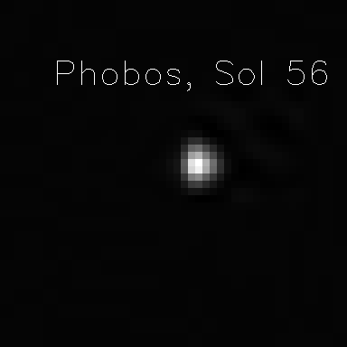
Mars' innermost natural satellite, Phobos, is seen from the planet's surface in this Pathfinder image taken at night on Sol 56. This picture was acquired by the Imager for Mars Pathfinder (IMP) camera. Using IMP images of Phobos and its companion moon Deimos, the spectral characteristics of the satellites and properties of the Martian atmosphere are determined. |
|
Mars' outermost natural satellite, Deimos, is seen from the planet's surface in this Pathfinder image taken at night on Sol 4. This picture was acquired by the Imager for Mars Pathfinder (IMP) camera. Using IMP images of Deimos and its companion moon Phobos, the spectral characteristics of the satellites and properties of the Martian atmosphere are determined. |
TwinPeaks_glyph_md.gif (Med - 730 KB) TwinPeaks_glyph.gif (Large - 2,183 KB) |
TwinPeaks_mono_md.jpg (Med - 264 KB) TwinPeaks_mono.jpg (Large - 365 KB) |
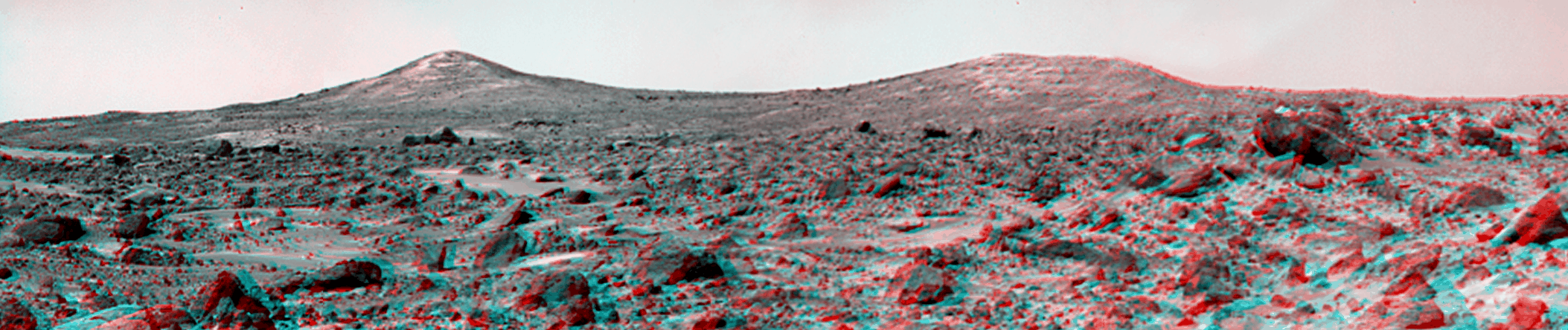
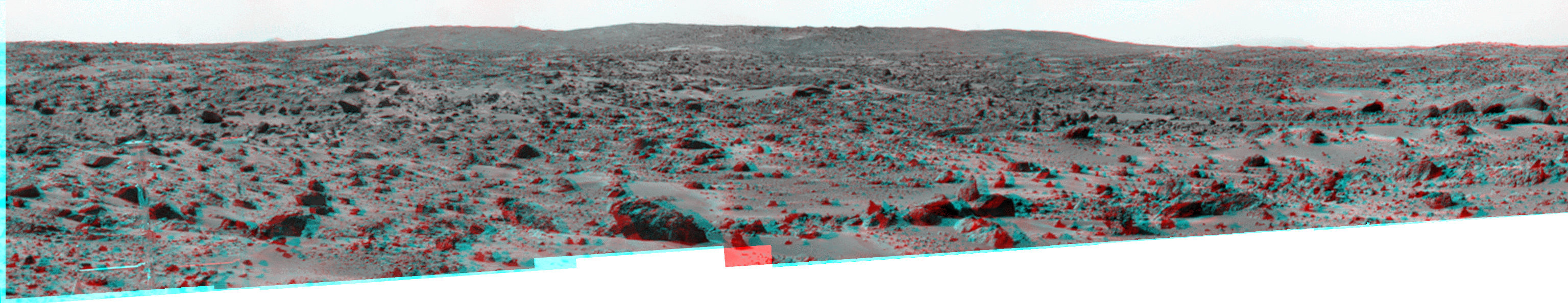
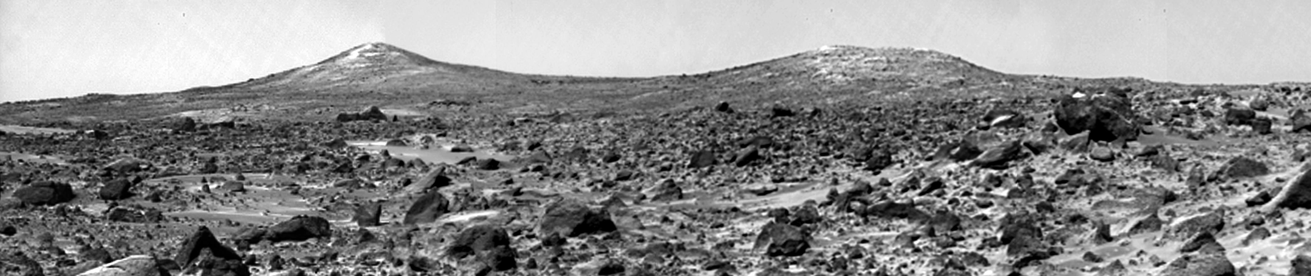
The Twin Peaks are modest-size hills to the southwest of the Mars Pathfinder landing site. They were discovered on the first panoramas taken by the IMP camera on the 4th of July, 1997, and subsequently identified in Viking Orbiter images taken over 20 years ago. The peaks are approximately 30-35 meters (~100 feet) tall. North Twin is approximately 860 meters (2800 feet) from the lander, and South Twin is about a kilometer away (3300 feet). The scene includes rocky ridges and swales (or "hummocks") of flood debris that range from a few tens of meters away from the lander to the distance of South Twin Peak. The large rock at the right edge of the scene is nicknamed "Hippo." This rock is about a meter (3 feet) across and 25 meters (80 feet) distant. This view of the Twin Peaks was produced by combining 4 individual "Superpan" scenes from the left and right eyes of the IMP camera to cover both peaks. Each frame consists of 8 individual frames (left eye) and 7 frames (right eye) taken with different color filters that were enlarged by 500% and then co-added using Adobe Photoshop to produce, in effect, a super-resolution panchromatic frame that is sharper than an individual frame would be. The anaglyph view of the Twin Peaks was produced by combining the left and right eye mosaics (above) by assigning the left eye view to the red color plane and the right eye view to the green and blue color planes (cyan), to produce a stereo anaglyph mosaic. This mosaic can be viewed in 3-D on your computer monitor or in color print form by wearing red-blue 3-D glasses. |
BigCrater_glyph_md.gif (Medium - 935 KB) BigCrater_glyph.gif (Large - 3,284 KB) |
BigCrater_mono_md.gif (Medium 1,405 KB) BigCrater_mono.gif (Large 4,928 KB) |
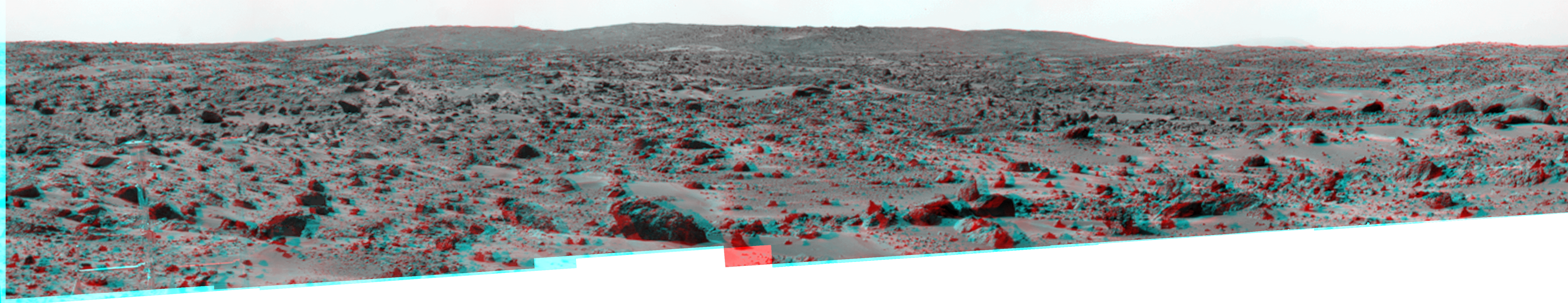
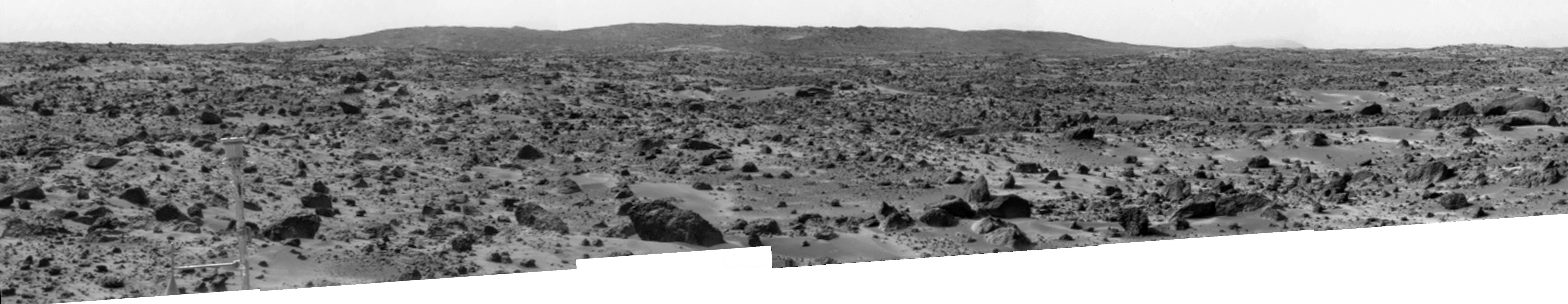
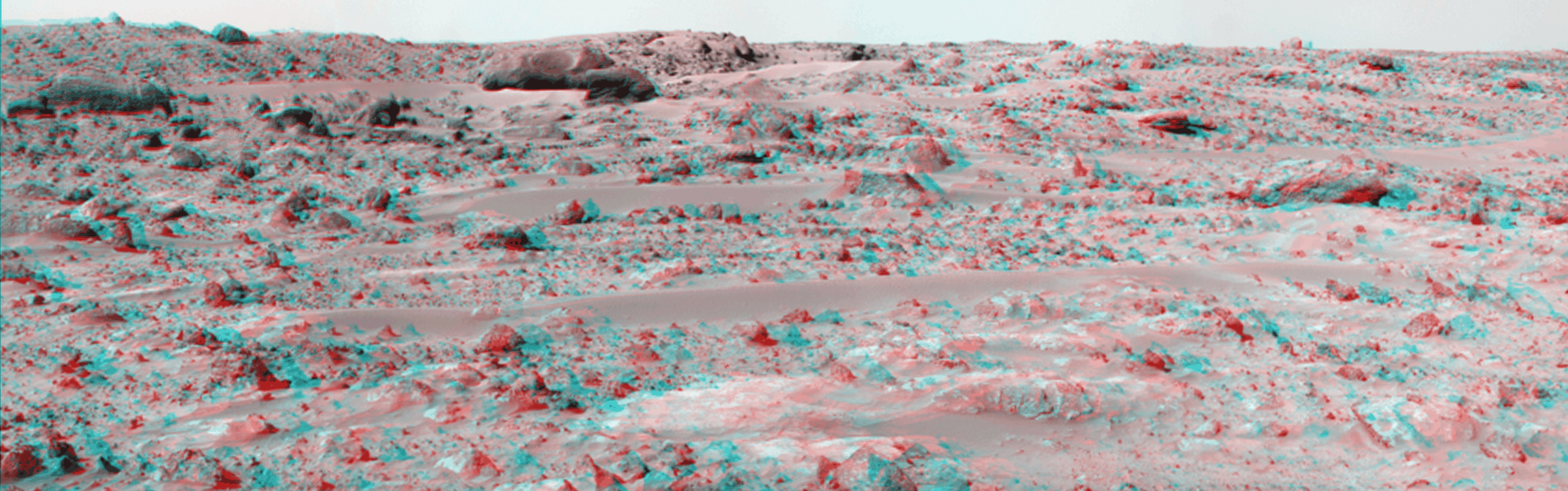
The "Big Crater" is actually a relatively small Martian crater to the southeast of the Mars Pathfinder landing site. It is 1500 meters (4900 feet) in diameter, or about the same size as Meteor Crater in Arizona. Superimposed on the rim of Big Crater (the central part of the rim as seen here) is a smaller crater nicknamed "Rimshot Crater." The distance to this smaller crater, and the nearest portion of the rim of Big Crater, is 2200 meters (7200 feet). To the right of Big Crater, south from the spacecraft, almost lost in the atmospheric dust "haze," is the large streamlined mountain nicknamed "Far Knob." This mountain is over 450 meters (1480 feet) tall, and is over 30 kilometers (19 miles) from the spacecraft. Another, smaller and closer knob, nicknamed "Southeast Knob" can be seen as a triangular peak to the left of the flanks of the Big Crater rim. This knob is 21 kilometers (13 miles) southeast from the spacecraft. The larger features visible in this scene - Big Crater, Far Knob, and Southeast Knob - were discovered on the first panoramas taken by the IMP camera on the 4th of July, 1997, and subsequently identified in Viking Orbiter images taken over 20 years ago. The scene includes rocky ridges and swales or "hummocks" of flood debris that range from a few tens of meters away from the lander to the distance of South Twin Peak. The largest rock in the nearfield, just left of center in the foreground, nicknamed "Otter", is about 1.5 meters (4.9 feet) long and 10 meters (33 feet) from the spacecraft. This view of Big Crater was produced by combining 6 individual "Superpan" scenes from the left and right eyes of the IMP camera. Each frame consists of 8 individual frames (left eye) and 7 frames (right eye) taken with different color filters that were enlarged by 500% and then co-added using Adobe Photoshop to produce, in effect, a super-resolution panchromatic frame that is sharper than an individual frame would be. The anaglyph view of Big Crater was produced by combining the left and right eye mosaics (above) by assigning the left eye view to the red color plane and the right eye view to the green and blue color planes (cyan), to produce a stereo anaglyph mosaic. This mosaic can be viewed in 3-D on your computer monitor or in color print form by wearing red-blue 3-D glasses. |
Zaphod_glyph_md.gif (Medium - 1,091 KB) Zaphod_glyph.gif (Large - 3,395 KB) |
Zaphod_mono_md.jpg (Medium - 329 KB) Zaphod_mono.jpg (Large - 519 KB) |
This panorama of the region to the northeast of the lander was constructed to support the Sojourner Rover Team's plans to conduct an "autonomous traverse" to explore the terrain away from the lander after science objectives in the lander vicinity had been met. The large, relatively bright surface in the foreground, about 10 meters (33 feet) from the spacecraft, in this scene is "Baker's Bench." The large, elongated rock left of center in the middle distance is "Zaphod." This view was produced by combining 8 individual "Superpan" scenes from the left and right eyes of the IMP camera. Each frame consists of 8 individual frames (left eye) and 7 frames (right eye) taken with different color filters that were enlarged by 500% and then co-added using Adobe Photoshop to produce, in effect, a super-resolution panchromatic frame that is sharper than an individual frame would be. This anaglyph view was produced by combining the left and right eye mosaics (above) by assigning the left eye view to the red color plane and the right eye view to the green and blue color planes (cyan), to produce a stereo anaglyph mosaic. This mosaic can be viewed in 3-D on your computer monitor or in color print form by wearing red-blue 3-D glasses. Copyright Jet Propulsion Laboratory, California Institute of Technology. Image processing and mosaic by Tim Parker, JPL. |


